
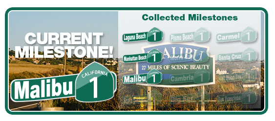
 At the beginning of April, I embarked on two (2) virtual walks. The first is sponsored by my employer and is called “The Big 1” and described as “The Big 1 takes you on a coastal voyage from Laguna Beach in the south all the way up to San Francisco. It is going to be a beautiful trip and your goal is to complete the route along the Pacific Coast Highway in six weeks.”

My team (Kansas City) is represented by a lightning bolt and is pretty much mid-pack and neck and neck with our ‘rival’ St. Louis. My team reached Malibu this week, the third milestone on the way to San Francisco.
Around the same time I received notice from my employer about our spring fitness challenge, I also saw a post from my local library Director inviting me to a similar challenge to walk across or around the State of Kansas. I immediately signed up for one of the three virtual walks offered by the K-State Extension Service – the one to walk across Kansas. I could have also walked diagonally or around all four borders of the state.

I’m a member of the Walking Well-Read team (as is the Library Director I mentioned above). This week our team made it to the 4th milestone heading west – a place called Kanwaka:

Kanwaka, Kansas is an unincorporated community of 1317 residents in Douglas County, 4 miles west of Lawrence. Kanwaka is a portmanteau (a name created by combining syllables of other words) of the KANsas and WAKArusa Rivers. The area was first settled in 1854 and had a post office from 1857 to 1870, and again from 1897 until 1900. Kanwaka is located at the intersection of U.S. Highway 40 and Stull Road although the name Kanwaka refers to an area, not a town.
The other three milestones were Kansas City, Kansas, Bonner Springs and Lawrence. I’m not sure what’s next, but I won’t have long to wait to find out.
For the first challenge (Big 1), all tracking is done automatically through my FitBit device. For Walk Kansas, I record the number of minutes each day that I walk or perform strength training exercises (which their web site then converts to miles to move us along the map westward). So for the second challenge, I use my FitBit’s exercise stopwatch to track exactly how long I walk over lunch and in the evenings. Here’s a sample of this week’s walking activities:
| Date | Activity | Steps | Distance | Duration | Calories |
|---|---|---|---|---|---|
| Apr 14, 7:07PM | Walking Porthos | 1,997 | 0.88 miles | 30:01 | 155 cals |
| Apr 14, 11:44AM | Lunch walk | 2,551 | 1.13 miles | 29:34 | 189 cals |
| Apr 13, 5:42PM | Walking Both Rotts | 2,341 | 1.04 miles | 25:18 | 167 cals |
| Apr 13, 11:41AM | Lunch walk | 3,059 | 1.35 miles | 32:09 | 216 cals |
| Apr 12, 6:49PM | Walking Both Rotts | 2,484 | 1.1 miles | 28:13 | 182 cals |
| Apr 12, 11:47AM | Lunch walk | 3,136 | 1.39 miles | 35:01 | 224 cals |
| Apr 11, 6:28PM | Walking Both Rotts | 3,243 | 1.44 miles | 38:10 | 236 cals |
| Apr 11, 11:51AM | Lunch walk | 3,787 | 1.68 miles | 37:30 | 266 cals |
| Apr 9, 11:10AM | Mowing Lawn | 4,040 | 1.79 miles | 35:01 | 281 cals |
Just based on raw steps recorded by my FitBit since April Fool’s day, I’ve got roughly 68 miles on my new pair of walking shoes, that I bought for my half birthday on April 2nd.

All this walking gives me plenty of time to listen to auidobooks. I recently finished Sense and Sensibility by Jane Austen and started The Art Forger by Shapiro. After that, I’ll be reading/listening to Kindred by Octavia Butler. Two of these three are book club reads and the current read is a follow-up to my recent reading of The Muralist for the FYI book club.
What a clever way to inspire more walking!